If you are citizen of an European Union member nation, you may not use this service unless you are at least 16 years old.
You already know Dokkio is an AI-powered assistant to organize & manage your digital files & messages. Very soon, Dokkio will support Outlook as well as One Drive. Check it out today!
Page history
last edited
by PBworks17 years, 7 months ago
Welcome
This is your one-stop center for Philippine markers and models for Google Earth.
Now sharing more than 1200 Philippine markers! Help us to build this site!
New!
Just added:
Guimaras Oilspill. We've created some image overlays from UNOSAT maps of the disaster area, and packaged that along with some standalone markers of affected areas posted by Cpee on Google Earth Community. To download, check out the link below, under "Environment".
Ateneo de Manila. Blue Eagles can thank Mr. Adrian Aguilar for this contribution.
Also...
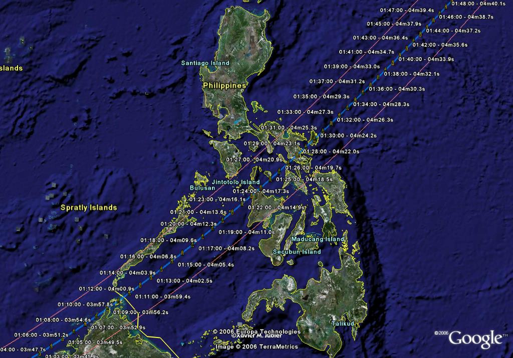
A fantasy railway system and something to do on Sunday...April 20, 2042. See 'Science/Solar Eclipse' and 'Mass Transit We'd Like to See'
Anyone may download any material posted and listed in this site.
To update/contribute to this wiki:
First, please email any KMZ/SketchUp contributions to philippinekmzs@gmail.com. Once we have validated and uploaded your first three contributions, we will give you the password so you can register and have direct editing capabilities for this wiki.
Here's a quick and dirty list of the KMZs you can download. We hope to grow this and then organize it for more efficient searching and downloading.
Metro Manila Landmarks
Metro Manila Landmarks. (Last update: June 25, 2006 -now in categories) Compile includes markers for Philippine Stock Exchange, Ayala Commercial Center, Christ the King, Makati CBD, Manila Sanitarium, Guadalupe Seminary, Lourdes School, Shangri-la Edsa Hotel, Mandaluyong City Hall, Ateneo High School, Miriam College, Ateneo de Manila, North Harbor, South Harbor, Fort Santiago, Arroceros Forest Park, Quiapo Mosque, Nagtahan Bridge, Polytechnic University of the Philippines, SM Sta. Mesa, Philippine Overseas Employment Agency, Robinsons Galleria, St. Paul's Pasig, Pasig Pumping Station (Manila Water Company), NAIA Terminal III, Libingan ng mga Bayani, Manila Central Temple, Philippine Sports Center, Pasig Capitolyo, Meralco Auditorium, Poveda Learning Center, Asian Development Bank, San Miguel Corporation, Shangri-la Mall, SM Megamall, Ortigas CBD, Ortigas Commercial Center, La Salle Greenhills, People Power Monument, EDSA Shrine, Camp Crame, Camp Aguinaldo, Wackwack Golf, SM Lagro, Angat Dam, La Mesa Watershed, La Mesa Dam, Batasang Pambansa (House of Representatives), Sandiganbayan, Celebrity Sports Plaza, Iglesia ni Cristo Central, New Era College, Asian Institute of Tourism, Department of Agriculture, Parks and Wildlife, Philcoa, Quezon Memorial Circle, Philippine Science High School, SM North EDSA, La Loma, Amoranto Stadium, Quezon City Hall, Pantranco, Sto. Domingo, Quezon Institute, University of Sto. Tomas, Malacañang, Quezon Bridge, Manila Observatory, Finance Building, National Museum, Metropolitan Theater, Mehan Gardens, Intramuros, Manila City Hall, San Lazaro Hippodrome, San Andres Market, Harrison Plaza, Department of Foreign Affairs, Cuneta Astrodome, Hyatt Hotel, CITEM, World Trade Center, Cultural Center of the Philippines, Folk Arts Theatre, Philippine International Convention Center, Manila Film Center, Asian Hospital, Alabang Market, DLS-Zobel School, Alabang Town Center, Festival Mall, Villamor Air Base, Manila Golf Club, American Cemetery, Rustan's, Filipinas Heritage Library, Ayala Museum, The Landmark Department Store, SM Makati, Asian Institute of Management, Don Bosco School, St. Andrews, Ateneo Law and Graduate School, Rockwell Center, Makati City Hall, Santuario de San Antonio, Manila Polo Club, San Agustin School, Dasmarinas Village Park, Assumption College, Salcedo Village Park, Urdaneta Village Park, New World Hotel, Oakwood Hotel, Hotel Intercontinental, Hotel Dusit Thani, Manila Peninsula, Shangri-la Makati, Mandarin Oriental Makati, Roxas Triangle, Glorietta, Greenbelt, Manila Cemetery, De La Salle University, St. Scholastica's College, Manila Hotel, Rizal Monument, Monumento, Veterans Memorial Medical Center, St. Luke's Hospital, Channel 9 Tower, Tomas Morato Circle, Nepa-Q-Mart, Philippine Children's Hospital, ABS-CBN, GMA 7, Kidney Center, Lung Center, Philippine Heart Center, Bureau of Internal Revenue, Philippine Mint, Local Water Utilities Administration, MWSS Building, Balara Filtration Plant, Eastwood City (Libis), Welcome Rotonda, Araneta Coliseum, Far Eastern University, Quiapo Church, Liwasang Bonifacio, Manila Post Office Building, Manila Cathedral, Rizal Park, Metropolitan Museum, Bangko Sentral ng Pilipinas, Manila Zoo, Adriatico Circle, Malate Church, Rizal Memorial Sports Complex, Philippine Senate (GSIS Building). Click here to download: http://googleearthphilippines.pbwiki.com/f/MMlandmarks_062406.kml
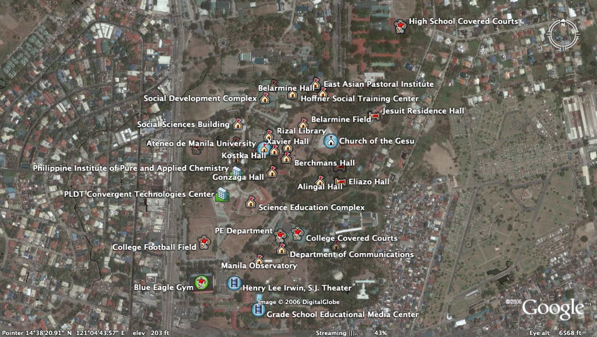
Ateneo de Manila Campus. Thanks to Adrian Aguilar for this contribution. Compile includes Belarmine Hall, Church of the Gesu, Philippine Institute of Pure and Applied Chemistry, Xavier Hall, Gonzaga Hall, Faura Hall, Rizal Library, Dela Costa Hall, Social Sciences Building, Colege and Covered Courts, PE Department, Cervini Hall, Eliazo Hall, Alingal Hall, Kostka Hall, Berchmans Hall, Science Education Complex, PLDT Convergent Technologies Center, Colayco Hall, Hoffner Social Training Center, Social Development Complex, Belarmine Field, Department of Communications, Arupe International Residence, Manila Observatory, Blue Eagle Gym, College Baseball Field, College Football Field, Henry Lee Irwin, S.J. Theatre, Grade School Educational Media Center, East Asian Pastoral Institute, Institute of Social Order, Jesuit Residence Hall, High School Covered Courts. Click here to download:http://googleearthphilippines.pbwiki.com/f/Ateneo%20de%20Manila%20University%20Campus.kmz
UP Diliman Campus
UP Diliman Campus. Compile includes markers for UP Film Center, UP Theater, Tennis Courts, Athletic Oval, Alumni Center, AIT, Phil. Atomic Energy Research Center, Arboretum, Instructional Media Corporation, College of Science, National Institute of Geology, College of Fine Arts, UP Integrated School, Phivolcs, Institute for Small Scale Industries, Vanguard Building, Military Science, College of Human Kinetics, UP Cooperative Center, UP Shopping Center, Kalayaan Hall, National Traffic Engineering Center, CASAA, Faculty Center (CAL), Palma Hall, College of Engineering, Asian Studies Center, International Center, Women's Pool, UP Health Services, Church of the Risen Lord, Parish of the Holy Sacrifice, Bahay ng Alumni, School of Urban and Regional Planning, College of Mass Communication, College of Music, UP Lagoon, Amphitheatre, UP Oblation, Quezon Hall, Palma Hall Annex, College of Home Economics, Main Library, School of Economics, College of Law, College of Education, Vinzons Hall, Sunken Garden, College of Business Administration). Click here to download: http://googleearthphilippines.pbwiki.com/f/UPPlaces_062206kmz.zip
To submit Google Earth material (SketchUp models and/or KMZ and KML files), please email us at philippinekmzs@gmail.com.
More Metro Manila Landmarks. Compile includes markers for Alabang Town Center, Cultural Center of the Philippines, Uniwide Coastal Mall, De La Salle University, Elizabeth Seton School, Festival Supermall, The Fort, Glorietta Mall, Greenbelt Mall, Intel Microelectronics Philippines, SM Megamall, Star Mall, Rizal Park-Luneta, Robinsons Mall, Shangri-la Mall, St. Joseph's Academy, SM Bacoor, SM City, SM South Mall, RFC Shopper Plaza, University of the Philippines Diliman, University of Perpetual Help, University of Sto. Tomas, Zapote FlyoverClick here to download: http://googleearthphilippines.pbwiki.com/f/68452-MetroManila-Schadow1.zip
To submit Google Earth material (SketchUp models and/or KMZ and KML files), please email us at philippinekmzs@gmail.com.
Major rivers and waterways in Metro Manila. Pasig, San Juan, Marikina and Tullahan Rivers plus the Manggahan Floodway. (Note: not from GIS files -these are just "traceovers" so they will not be geographically accurate. Click here to download:http://googleearthphilippines.pbwiki.com/f/MajorWaterways.kmz
Waterfront Opportunities
Opportunities for redevelopment along our rivers. Fourteen sites near the confluences of the Pasig and San Juan and the Pasig and Marikina rivers that would be great to redevelop into waterfront parks + commercial or business real estate.Click here to download:http://googleearthphilippines.pbwiki.com/f/waterfrontopportunities.kml
Bus Rapid Transit or Tram lines (surface rail). For lines (red, blue, yellow and green) to connect emerging and existing employment and commercial centers with residential areas. Click here to download:http://googleearthphilippines.pbwiki.com/f/ProposedQCBRTLines.kml
Baguio. This is one heck of a starter kit for the Pine City. Thanks to Caesar Angeles, a self-described Google Earth 'beginner'--but aren't we all? Caesar's done his best to add notes to a lot of markers, but he indicates it's still a work in progress. Still, all in all an exhaustive collection for one of our favorite cities. Click here to download:http://googleearthphilippines.pbwiki.com/f/Baguio%20Placemarks.kmz
To submit Google Earth material (SketchUp models and/or KMZ and KML files), please email us at philippinekmzs@gmail.com.
We've created some image overlays from UNOSAT maps of the disaster area, and packaged that along with some standalone markers of affected areas posted by Cpee on Google Earth Community ( http://bbs.keyhole.com/ubb/showflat.php?Cat=0&Number=568879 ). The KMZ compile here has those markers plus the image overlays, available in one download. Click here to download:Guimaras oil spill.kmz
Mining Sites
Potential Sites
Potential Mining Sites in the Philippines. From the Philippine Mineral Sector briefing report submitted to the Mines and Geosciences Bureau in 2005. These KMZs are no longer available for download from the online report (there are links for downloads, but no cigar) at http://www.imaginet.com.ph/mining_main.htm , but we found them posted in another website. The markers have links to more detailed information contained in the same briefing kit mentioned above. Click here to download:http://googleearthphilippines.pbwiki.com/f/Mining_in_the_Philippines.kmz
Operating Sites
Operational and Pending Mining Activities in the Philippines. Related to Potential Mining Sites in the Philippines listed above, and contained in the same Philippine Mineral Sector briefing report submitted to the Mines and Geosciences Bureau in 2005. These KMZs are no longer available for download from the online report (there are links for downloads, but no cigar) at http://www.imaginet.com.ph/mining_main.htm , but we found them posted in another website. The markers have links to more detailed information contained in the same briefing kit mentioned above. Click here to download:http://googleearthphilippines.pbwiki.com/f/Operating_Mines_in_the_Philippines.kmz
To submit Google Earth material (SketchUp models and/or KMZ and KML files), please email us at philippinekmzs@gmail.com.
Philippines Google Earth Tour. A virtual "helicopter tour" of 29 highly-recommended destinations all around the archipelago. This was downloaded from Our Awesome Planet, a blog run by Anton Diaz. http://anton.blogs.com/awesome/2005/11/first_philippin.html . The KML file includes markers for Pagudpud, Vigan, Banaue Rice Terraces, Hundred Islands, Subic Bay Freeport Zone, Laguna de Bay, Puraran in Catanduanes, Mount Mayon, Boracay, El Nido, Puerto Galera, Anilao, Bantayan Island, Mount Apo, and much more. All markers also link to relevant wikipedia pages for updated info. Click here to download: http://googleearthphilippines.pbwiki.com/f/Phils_Google_Earth_Tour.kml
Tanawing Pinoy. More areas of note across the Philippines (and beyond), courtesy of Tanawing Pinoy, a blog that features screenshots of national sites as seen from Google Maps. See http://forge.codedgraphic.com/tanawin/ . This KML includes markers for the Cagsawa Ruins in Daraga, Albay, Burnham Park in Baguio, Enchanted Kingdom, San Roque Dam, and the country's northern-most island, Y'ami. And there's a lot more. The 'tour' does in fact stray outside the Philippines: Rizal Park on Beacon Hill in Seattle, Washington, Jollibee's branch in Daly City, and Philippine Ambassador residences in Japan and London. Markers are also embedded with data and historical info on the locations. Click here to download: http://googleearthphilippines.pbwiki.com/f/tanawing_pinoy.kml
Assorted Points of Interest Thanks to Erik Peterzen--some sites worth seeing, and some places worth staying in.
World Heritage Sites in the Philippines. Derived from UNESCO's compiled KMZs for World Heritage Sites. The Philippine folder, made available here, has five markers for Tubbataha Reef, the Cordillera Rice Terraces, Vigan, and the Puerto Princessa Subterranean River National Park, and "Baroque Churches" (one marker for 16th century churches in Manila, Santa Maria, Paoay and Miag-ao.) KMZs link to pictures and more info on the UNESCO World Heritage website. Click here to download:http://googleearthphilippines.pbwiki.com/f/World%20Heritage-Philippines.kmz
To submit Google Earth material (SketchUp models and/or KMZ and KML files), please email us at philippinekmzs@gmail.com.
Philippine Airports. NAIA Terminals and ALL airports around the archipelago. Includes technical data. This is derived from a global KMZ tediously built up, compiled, and posted by Herrminator of Bacolod City at http://bbs.keyhole.com/ubb/showflat.php?Number=184700 . Herrminator's laborious work at the Google Earth Community BBS contains more than 10,000 airport markers worldwide. That's enough, he warns, to potentially crash a weak-hearted computer. We've saved here just the KMZs for the Philippines--which by themselves number more than you realize. Click here to download:http://googleearthphilippines.pbwiki.com/f/Philippine%20Airports.kmz
Agrarian Reform Beneficiaries. Tags a handful of agrarian reform beneficiaries as local producers, manufacturers, and handicraft centers. Hopefully this will bridge local communities with foreign and local investors and entrepreneurs. Click here to download: http://googleearthphilippines.pbwiki.com/f/darplaces.zip
To submit Google Earth material (SketchUp models and/or KMZ and KML files), please email us at philippinekmzs@gmail.com.
Path of Solar Eclipse Viewable in the Philippines on April 20, 2042. From the website of Frenchman Xavier Jubier. If you want more solar eclipse KMZs, check out his site. Here's a page link that'll help you chase the moon's and earth's shadows all over the world till the end of the 21st century: http://xjubier.free.fr/en/site_pages/SolarEclipsesGoogleEarth.html. But if you intend to just catch the show from your street, mark your calendar for April 20, 2042. That's a Sunday. Click here to download:http://googleearthphilippines.pbwiki.com/f/solar-eclipse-rp.kmz
To submit Google Earth material (SketchUp models and/or KMZ and KML files), please email us at philippinekmzs@gmail.com.
Bicol Data and Shapefiles. Courtesy of Naga City's GIS guys, a whole lot of data and KMZs that provide more geographic feature illustrations--roads, rivers, slopes, etc.--for the whole Bicol Region. Click here to download:http://googleearthphilippines.pbwiki.com/f/bicoldata.zip
Naga City Building Footprints. 3D placemarks for buildings in Naga City. Pretty extensive -- KMZ file is 949 KB -- and very impressive. Once again contributed by Senen Ebio, whose Naga City Population Visualization Tool is listed above. Click here to download:http://googleearthphilippines.pbwiki.com/f/Naga%20Building%20Footprints.kmz
Naga City On Google Earth
Naga City Buildings + Roads + Landuse Click this, this, and this for a virtual Naga City tour (Google Earth 4 needed!). More maps and data at the Naga GIS Site.
To submit Google Earth material (SketchUp models and/or KMZ and KML files), please email us at philippinekmzs@gmail.com.**

Comments (0)
You don't have permission to comment on this page.